Cool, very wet in the South and East
January 2026 was a cool and wet month, with most stations recording monthly rainfall totals above their 1991-2020 Long Term Average (LTA). In the second half of the month, repeated frontal rainbands moved over Ireland from the south due to a cold blocking high pressure over northern and eastern Europe and slow moving low pressure systems to the southwest. This resulted in prolonged spells of heavy rain leading to significant flooding in the Southeast and East during and after Storm Chandra. The storm brought strong winds and heavy rain on 26th and 27th, with more rainfall continuing to pass over the South and East up to the end of the month. January 2026 was a cool month overall, with the coldest temperatures recorded in the first week. Overall, the average recorded temperatures make January 2026 the coldest January since 2021, with all stations below their 1991-2020 LTA temperatures for the month.
Key Figures:
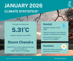
- Ireland rainfall was 123% of the 1991-2020 LTA (164mm) and ranked 18th wettest nationally and the wettest since 2018.
- County Dublin observed its 2nd wettest January on record with both Phoenix Park (225% of its LTA) and Dublin Airport (223% of its LTA) having their 2nd wettest January behind January 1948.
- Johnstown Castle, Co Wexford was the wettest synoptic station in January with 232.7 mm (230% of its LTA), its wettest January since 1996.
- The rolling three month total at Johnstown Castle, Co Wexford for November 2025, December 2025 and January 2026 is the highest consecutive three month total on record for Johnstown Castle with 652.5 mm over the three months (00-00 values, record length 85 years).
- The national mean air temperature of 5.31°C (using the Island of Ireland dataset*) making January 2026 the 59th coldest in 127 years and the coldest January since 2021.
- 5.31 °C is 0.51 °C below the 1991-2020 LTA and 0.22 °C above the 1961-1990 LTA.
January Climate Statement highlights
January 2026 began cold and mostly dry with spells of crisp winter sunshine and widespread frost at night. High pressure to the west steered a cold Arctic airmass over Ireland in a northerly airflow. This brought occasional wintry showers, particularly across Northern and Northwestern areas where some snowfall accumulated at times. High pressure pulled away to the north at the end of the first week allowing Atlantic low pressure to dominate for the rest of the month. The second week saw frequent bands of rain and showers moving in from the west while it became somewhat milder.
During the second half of January, a strong southerly displaced North Atlantic jet stream directed a succession of low pressure systems toward the country from the southwest. At the same time, a cold blocking high pressure over northern and eastern Europe caused these systems to slow or stall to the southwest of Ireland and meander northwards. This pattern resulted in repeated frontal rainbands moving up from the south, giving prolonged spells of heavy rain, concentrated over the South and East of the country. The cumulative effect of the prolonged wet spell for the South and East caused significant flooding in places. A notable event during this period was Storm Chandra, named by the UK Met Office, which rapidly deepened to the south of Ireland on Monday 26th. As it tracked north late on the 26th into Tuesday 27th, it brought strong winds and widespread heavy rainfall. The month finished with further bands of rain or showers, mainly affecting the South and East.
Rainfall: Above average in most places, wettest in the South and East
The majority of monthly rainfall totals were above their 1991-2020 Long-Term Average (LTA). Percentage of monthly rainfall values ranged from 87% (the month’s lowest monthly rainfall total of 90.5 mm) at Shannon Airport, Co Clare to 230% (the month’s highest monthly rainfall total of 232.7 mm) at Johnstown Castle, Co Wexford (its wettest January since 1996). The month’s wettest day was also recorded at Johnstown Castle, Co Wexford with 37.3 mm on Friday 30th (its highest daily fall for January since 1979). The number of rain days* ranged from 22 days at Casement Aerodrome, Co Dublin to 30 days at both Newport, Co Mayo and Valentia Observatory, Co Kerry. The number of wet days* ranged from 16 days at both Athenry, Co Galway and Mount Dillon, Co Roscommon to 27 days at Valentia Observatory, Co Kerry. The number of very wet days* ranged from 1 day at Shannon Airport, Co Clare to 9 days at both Johnstown Castle, Co Wexford and Valentia Observatory, Co Kerry.
It was the wettest January since 1948 and 2nd wettest on record at both Phoenix Park, Co Dublin with 141 mm (225% of its LTA) and Dublin Airport, Co Dublin with 137.7 mm (223% of its LTA). It was the wettest January since 1995 at Casement Aerodrome, Co Dublin with 114.5 mm (176% of its LTA). Oak Park, Co Carlow has its wettest January since 2014 with 142.3 mm (177% of its LTA) and both Cork Airport with 200.5 mm (153% of its LTA) and Moore Park, Co Cork with 143.7 mm (131% of its LTA) had their wettest January since 2016.
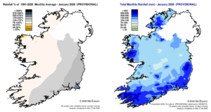
Rainfall % of 1991 – 2020 Monthly Average for January 2026 (Provisional) Total Monthly Rainfall (mm) for January 2026 (Provisional)
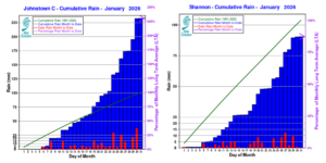
Cumulative rainfall totals at Johnstown Castle, Co Wexford (left) and Shannon Airport, Co Clare (right) in January 2026, relative to monthly 1991-2020 long term average (09-09 valuea)
Temperature: Below average everywhere
All mean air temperatures across the country were below their LTA for the month. Deviations from mean air temperature ranged from -1.0 °C at Moore Park, Co Cork and Valentia Observatory, Co Kerry (4.6 °C, 6.5 °C mean temperatures respectively) to -0.2 °C at Markree, Co Sligo (4.6 °C mean temperature). Mean temperatures for the month ranged from 3.9 °C (0.4 °C below its LTA) at Knock Airport, Co Mayo to 6.9 °C (0.8 °C below its LTA) at Sherkin Island, Co Cork. The month’s highest temperature was reported at Phoenix Park, Co Dublin on Sunday 11th with a temperature of 13.6 °C. The month’s lowest air minimum was recorded on Sunday 4th at Athenry, Co Galway with -5.3 °C while the lowest grass minimum was -10.2 °C reported at Casement Aerodrome, Co Dublin on Monday 5th. All stations reported ground frost during the month. The number of days with ground frost ranged from 9 days at Mace Head, Co Galway to 23 days at Markree, Co Sligo. More than half of stations reported air frost. The number of days with air frost ranged from zero days at a few stations to 13 days at Moore Park, Co Cork.
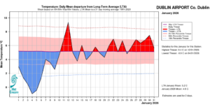
Dublin Airport, Co Dublin Temperature: Daily mean departure from LTA for January 2026 based on 09-09hr Max/Min values.
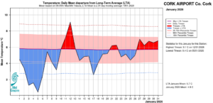
Cork Airport, Co Cork Temperature: Daily mean departure from LTA for January 2026 based on 09-09hr Max/Min values.
Sunshine: Generally above average, sunniest in the South
All available sunshine totals were above their LTA, with the first half of January much sunnier than the second half. Percentage of monthly sunshine values ranged from 112% (58.9 hours) at Shannon Airport, Co Clare to 119% (64.0 hours) at Casement Aerodrome, Co Dublin. Monthly sunshine totals ranged from 47.8 hours (No LTA comparison*) at Malin Head, Co Donegal to 75.0 hours (No LTA comparison*) at Cork Airport, Co Cork. The highest number of daily sunshine hours recorded this month was 7.2 hours at Johnstown Castle, Co Wexford on Monday 5th. The number of dull days* ranged from 8 days at Valentia Observatory, Co Kerry to 14 days at both Malin Head, Co Donegal and Casement Aerodrome, Co Dublin.
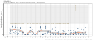
Hours of Bright Sunshine observed at nine stations for each day of the month of January 2026, grouped by province relative to the highest number of hours possible by end of month (shaded box).
Wind: Storm force winds reported during storm Chandra at one station
Monthly mean wind speeds ranged from 5.3 knots (9.8 km/h) at Moore Park, Co Cork to 18.9 knots (35.0 km/h) at Malin Head, Co Donegal. Gales were reported on fourteen days. Strong gales reported on Sunday 25th at Malin Head, Co Donegal and on Tuesday 27th at Malin Head, Co Donegal and Mace Head, Co Galway during storm Chandra. Storm force winds were reported on Tuesday 27th at Malin Head, Co Donegal during storm Chandra. The number of days with gales ranged from zero days at most stations to 13 days at Malin Head, Co Donegal. The number of days with up to strong gales ranged from zero at most stations to 2 days at Malin Head, Co Donegal. Both the month’s highest gust and 10-minute mean wind speeds were reported at Malin Head, Co Donegal on Tuesday 27th during storm Chandra. The highest gust was 70 knots (130 km/h) while the month’s highest 10-minute mean wind speed was 56 knots (104 km/h).
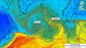
Airmass Analysis chart 12 UTC 27 January 2026: Storm Chandra moved north along the west of Ireland steering up active weather fronts from the south.
Full PDF report and charts are available here
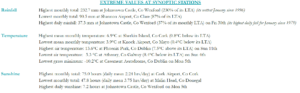
Extreme values for January 2026 at synoptic stations.
Notes to Editor:
- *Issued by Met Éireann on Wednesday 4th February 2026. This report is based on available preliminary data from 25 principal weather stations operated by Met Éireann. Synoptic station data is midnight to midnight UTC. Long-Term Averages (LTAs) and “average” refer to the period 1991-2020 unless stated.
- A rain day is a day on which 0.2 mm or more of rainfall is measured. A wet day is a day with 1.0 mm or more of rainfall. A dull day is a day with less than 0.5 hours of sunshine. A very wet day is a day with 10.0 mm or more of rainfall.
- Climatological dry periods – An absolute drought is a period of 15 or more consecutive days to none of which is credited 0.2 mm or more of precipitation. A partial drought is a period of at least 29 consecutive days, the mean daily rainfall of which does not exceed 0.2 mm. A dry spell is a period of 15 or more consecutive days to none of which is credited 1.0 mm or more of precipitation (i.e. daily tot < 1.0 mm).
- A heatwave occurs where there are 5 consecutive days or more with maximum temperature over 25°C (that is, a daily maximum screen air temperature > 25° C).
- The ‘Island of Ireland’ dataset is 125 years long and runs between 1900 and 2023. For this dataset the long term averages from the 1961-1990 reference period are used for comparison as is standard for long-term climate change assessments.
- Sunshine data is from the Autosol Network. LTAs for these sites are currently not used for comparison purposes.
- For more information or interview opportunities with a Met Éireann spokesperson, please contact us at enq@met.ie.