Very mild, wet and dull
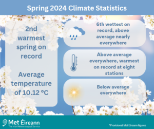
- Overall (using the Island of Ireland dataset*), Spring 2024 was the 2nd warmest spring on record (record length 125 years) with an average temperature of 10.12 °C, which is 1.75 °C above the 1961-1990 long term average (LTA) or 1.00 °C above the 1991-2020 LTA spring temperature.
- This is the 4th time that the average Spring temperature exceeded 10 °C (the others being 1945, 2017 & 2023). The warmest spring was in 1945 with an average temperature of 10.26 °C and the coldest was spring 1979 (46 years ago) with an average temperature 6.96 °C.
- Provisional gridded rainfall data suggests Spring 2024 was the 6th wettest on record (record length of 84 years), with 124% of its 1981-2010 average. The wettest Spring was in 1947 (77 years ago) and driest spring was in 1944 (80 years ago).
Spring 2024 Climate Statistics
Spring 2024 was one of the warmest and wettest springs on record. It was the twelfth consecutive season with above average temperatures and the fifth with above average rainfall. Record high sea surface temperatures continued across the North Atlantic, helping to boost the mean temperatures and moisture content in the atmosphere. A southerly displaced jet stream during much of March and at times during April steered numerous low pressure systems over or to the south of Ireland. This led to a wet spring for the Midlands, South and East, while the Northwest escaped with slightly below average rainfall. High night-time temperatures were a feature during the season, which boosted the overall mean temperatures. It was a dull season with below average sunshine. The cloudy conditions also helped to keep the nights warmer. Storm Kathleen, named by Met Éireann, brought the windiest period of the season on Saturday 6th April as a deep low pressure system moved north close to the west coast. There were three periods late in the season, Saturday 20th to Wednesday 24th April, Saturday 4th to Saturday 11th May and Saturday 18th to Thursday 23rd May, where high pressure took control and brought much needed drier conditions. Thundery downpours featured in places between Sunday 12th and Tuesday 21st May.
Rainfall: Above average nearly everywhere, wet March and April, drier May in places
- Moore Park, Co Cork and Johnstown Castle, Co Wexford had their wettest spring since 1981.
- Phoenix Park, Co Dublin and Mount Dillon, Co Roscommon had their wettest spring day on record.
Nearly all rainfall totals were above their 1981-2010 Long-Term Average (LTA) for the season. Percentage of seasonal rainfall values ranged from 85% (seasonal rainfall total of 218.2 mm) at Finner, Co Donegal to 167% (seasonal rainfall total of 363.4 mm) at Johnstown Castle, Co Wexford. Seasonal rainfall totals ranged from 188.4 mm (117% of its LTA) at Casement Aerodrome, Co Dublin to 421.0 mm (134% of its LTA) at Valentia Observatory, Co Kerry. The highest daily rainfall total was 45.3 mm at Dublin Airport, Co Dublin on Friday 1st March (its highest daily fall for spring since 2002). The number of rain days* ranged from 50 days at Mace Head, Co Galway to 69 days at Mullingar, Co Westmeath. The number of wet days* ranged from 39 days at Phoenix Park, Co Dublin to 54 days at both Mullingar, Co Westmeath and Cork Airport, Co Cork. The number of very wet days* ranged from 3 days at both Phoenix Park and Dublin Airport, Co Dublin to 16 days at Cork Airport, Co Cork. Mount Dillon, Co Roscommon had its wettest spring on record with 351.3 mm (record length 18 years). Moore Park, Co Cork with 312.8 mm and Johnstown Castle, Co Wexford with 363.4 mm had their wettest spring since 1981. Phoenix Park, Co Dublin with 43.9 mm on Friday 1st March (length 83 years) and Mount Dillon, Co Roscommon with 33.6 mm Thursday 14th March (length 18 years) had their wettest spring day on record.
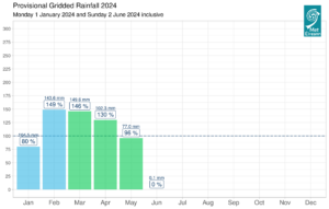
Provisional monthly gridded 2024 rainfall anomalies so far (% of 1981-2010) together with monthly rainfall totals
Temperature: Above average everywhere, warmest on record at eight stations
- Eight stations had their warmest spring on record (record lengths 15 – 125 years).
- Fifteen stations had their highest mean minimum for spring on record, indicating how high night-time temperatures helped to increase the overall mean temperatures for spring.
All mean air temperatures across the country were above their LTA for the season. Deviations from mean air temperature ranged from 0.6 °C (10.2 °C mean temperature) at Mace Head, Co Galway to 1.7 °C (10.2 °C mean temperature) at Phoenix Park, Co Dublin (its warmest spring on record (record length 125 years)). Mean temperatures ranged from 8.8 °C (1.1 °C above its LTA) at Knock Airport, Co Mayo to 10.8 °C (0.9 °C above its LTA) at Sherkin Island, Co Cork. All the season’s highest and lowest temperatures were recorded at Mount Dillon, Co Roscommon with the lowest air minimum reported on Friday 29th March with a temperature of -2.7 °C while the highest maximum was reported on Monday 20th May with a temperature of 24.6 °C. The lowest grass minimum was on Saturday 27th April with -7.4 °C. Most stations reported ground frost. The number of days with ground frost ranged from zero days at both Sherkin Island, Co Cork and Valentia Observatory, Co Kerry to 34 days at Mount Dillon, Co Roscommon. Just over half of stations reported air frost. The number of days with air frost ranged from zero days at a few stations to 10 days at Markree, Co Sligo. Eight stations, including Phoenix Park, had their warmest spring on record (record lengths 15 – 125 years). These were Oak Park, Co Carlow with a mean temperature of 10.3 °C (1.5 °C above its LTA), Moore Park, Co Cork with 10.2 °C (1.3 °C above its LTA), Roches Point , Co Cork with 10.4 °C (1.0 °C above its LTA), Markree, Co Sligo with 9.4 °C (0.7 °C above its LTA), Dunsany, Co Meath with 9.8 °C (1.5 °C above its LTA), Athenry, Co Galway with 9.9 °C (0.8 °C above its LTA) and Casement Aerodrome, Co Dublin with 10.0 °C (1.5 °C above its LTA). Dublin Airport had its warmest spring since 1990 with a mean temperature of 9.6 °C (1.0 °C above its LTA). Johnstown Castle, Co Wexford with 10.0 °C (1.0 °C above its LTA) and Cork Airport, Co Cork with 9.8 °C (1.1 °C above its LTA) both had their warmest spring since 2007. Fifteen stations had their highest mean minimum for spring on record, indicating how high night-time temperatures helped to increase the overall mean temperatures for spring.
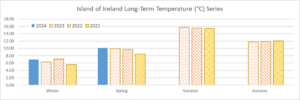
Average Meteorological Seasonal Temperatures (using the Island of Ireland dataset*) for 2021, 2022, 2023 and 2024 so far.
Sunshine: Below average everywhere
- Casement Aerodrome, Co Dublin and Shannon Airport, Co Clare had their dullest spring since 2014.
- Dublin Airport had its dullest spring since 1996.
- Cork Airport had its dullest spring on record (length 61 years).
All available monthly sunshine totals were below their LTA for the season. Percentage of seasonal sunshine values ranged from 90% (seasonal sunshine total of 396.2 hours) at Casement Aerodrome, Co Dublin (its dullest spring since 2014) to 95% (the season’s highest seasonal sunshine total of 415.3 hours) at Shannon Airport, Co Clare (its dullest spring since 2014). Seasonal sunshine totals were lowest at Gurteen, Co Tipperary with 354.3 hours (No LTA comparison*). The highest number of daily sunshine hours recorded this season was 14.9 hours at both Johnstown Castle, Co Wexford on Sunday 19th May and Cork Airport, Co Cork and Monday 20th May. The number of dull days* ranged from 18 days at both Johnstown Castle, Co Wexford and Casement Aerodrome, Co Dublin to 24 days at both Gurteen, Co Tipperary and Cork Airport. Dublin Airport reported its dullest spring since 1996 with 379.9 hours while Cork Airport reported its dullest spring on record with 359 hours (length 61 years).
Wind: Strong gales reported during storm Kathleen
Seasonal mean wind speeds ranged from 6.1 knots (11.3 km/h) at Ballyhaise, Co Cavan to 14.1 knots (26.1 km/h) at Malin Head, Co Donegal. Gales were reported on numerous days with up to strong gales reported on Tuesday 5th Mar, Wednesday 27th Mar and Sunday 6th Apr during storm Kathleen. The number of days with gales ranged from zero days at a few stations to 13 days at Malin Head, Co Donegal. The number of days with up to strong gales ranged from zero days at most stations to 2 days at both Mace Head, Co Galway and Malin Head, Co Donegal. The season’s highest 10-minute mean wind speed of 46 knots (85 km/h) was reported at Sherkin Island, Co Cork, Roche’s Point, Co Cork and Belmullet, Co Mayo during storm Kathleen on Saturday 6th April. The highest gust of 61 knots (113 km/h) was reported at Finner, Co Donegal, also on the Saturday 6th April.
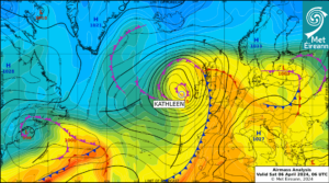
Airmass Analysis chart 06 UTC 6 April 2024: Storm Kathleen moving northwards along the west coast.
The full report is available here (choose Spring on drop down menu for month) or the PDF is available here
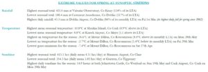
Extreme values for spring 2024 at synoptic stations
*Issued by Met Éireann on Thursday 2nd May 2024. This report is based on available preliminary data from 25 principal weather stations operated by Met Éireann. Synoptic station data is midnight to midnight UTC. Long-Term Averages (LTAs) and “average” refer to the period 1981-2010 unless stated. A rain day is a day on which 0.2 mm or more of rainfall is measured. A wet day is a day with 1.0 mm or more of rainfall. A dull day is a day with less than 0.5 hours of sunshine. A very wet day is a day with 10.0 mm or more of rainfall. Climatological dry periods – An absolute drought is a period of 15 or more consecutive days to none of which is credited 0.2 mm or more of precipitation. A partial drought is a period of at least 29 consecutive days, the mean daily rainfall of which does not exceed 0.2 mm. A dry spell is a period of 15 or more consecutive days to none of which is credited 1.0 mm or more of precipitation (i.e. daily tot < 1.0 mm). A heatwave occurs where there are 5 consecutive days or more with maximum temperature over 25°C (that is, a daily maximum screen air temperature > 25° C). The Island of Ireland dataset is 125 years long and runs between 1900 and 2023. For this dataset the long term averages from the 1961-1990 reference period are used for comparison as is standard for long-term climate change assessments. *Sunshine data is from the Autosol Network. LTAs for these sites are currently not used for comparison purposes. For more information, contact Met Éireann at 01-8064200 or e-mail: enq@met.ie