Warm, dry, calm and very sunny May for Ireland
It was a mild, dry and sunny May for Ireland in 2025, with the average temperature among the warmest on record, and rainfall levels notably low.
- Provisionally, the May 2025 average temperature of 12.54 °C made it the sixth highest for May in 126 years of records.
- In keeping with the trend of a consistent warming signal for May in Ireland, the top seven highest average May temperatures have occurred since 2008, with 2024 out in front with an average temperature of 13.08 °C.
- The average temperature for May 2025 was 1.85 °C above the 20th century (1901-2000) average for the month and 1.21 °C above the long-term average for the most recent climatological reference period of 1991-2020.
- Provisional gridded rainfall data suggests May 2025 averaged around 56mm, representing 70% of the month’s long-term average from 1991-2020.
- 2025 ranks as the 23rd driest May in records since 1941 and the fourth consecutive year to have below the long-term average rainfall for the month.
- 20 weather stations across the country recorded climatological dry spells – periods of 15 or more consecutive days with less than 1.0 mm of rainfall – from end of April into May.
- Total hours of sunshine from all available locations were above the long-term average for 1991-2020, with two stations recording their highest ever monthly sunshine totals, and a couple of others their highest totals for May.

May 2025 Statistics
May 2025 was warm, dry and very sunny overall. Blocking high pressure, positioned mostly to the north of Ireland, dominated for the first three weeks of the month with Atlantic low pressure breaking through in the final week. The month began warm, especially in the South, before a weak cold front moved south, introducing a slightly cooler airmass. High pressure soon re-established just to the north of the country and brought a dry and mostly sunny first week and a half, as it gradually warmed up again.
A slack area of low pressure tried to push up from the south between Sunday 11th and Wednesday 14th, introducing instability and activating some scattered showers and thunderstorms in places. Rainfall amounts stayed low in most places. Blocking high pressure again re-established to the north between Thursday 15th and Thursday 22nd, bringing a lot of dry and sunny conditions, while always warmest in the Midlands, South and West due to the easterly airflow.
The abundant sunshine and slack easterly airflow intensified the marine heatwave off the south and west coasts that had been building through April. A cold pool aloft introduced instability on Monday 19th and Tuesday 20th, which resulted in scattered, intense thunderstorm activity. Some places saw heavy downpours while other places had little or no rain.
Atlantic weather fronts finally broke through on Friday 23rd, introducing a slightly cooler westerly airflow. The final week of the month saw westerly winds return with low pressure to the north steering several frontal rain bands across the country, interspersed with sunshine and showers.
Rainfall: Dry, especially in the South
Nearly all rainfall totals were below their 1991-2020 Long-Term Average (LTA). Percentage of monthly rainfall values ranged from 31% (the month’s lowest monthly rainfall total of 19.9 mm) at Roches Point, Co Cork (its driest May on record, length 18 years) to 104% (monthly rainfall total of 79.2 mm) at Finner, Co Donegal.
Monthly rainfall totals were as much as 88.2 mm (89% of its LTA) at Newport, Co Mayo. The highest daily rainfall total was 19.3 mm at Casement Aerodrome, Co Dublin on Tuesday 20th.
The number of rain days (*0) ranged from eight days at a few stations to 13 days at Casement Aerodrome, Co Dublin. The number of wet days (*1) ranged from five at both Roches Point, Co Cork and Johnstown Castle, Co Wexford, to 11 at Phoenix Park, Co Dublin.
The number of very wet days (*2) ranged from zero at a few stations to four at Newport, Co Mayo.
There were numerous climatological dry periods (*3) ending in May. 20 stations experienced these periods, between 26th April and 22nd May, lasting between 15 and 27 days (Athenry, Co Galway and Mount Dillon, Co Roscommon). 11 stations had absolute droughts (*4), between April 26th and May 22nd, lasting between 15 and 25 days (Athenry, Co Galway). Two stations observed partial droughts (*5), from April 26th to May 25th, lasting 30 days (Moore Park, Co Cork and Roches Point, Co Cork). Four stations had consecutive zero rainfall days: 22 consecutive days at Moore Park, Co Cork, 23 consecutive days at Mullingar, Co Westmeath and both Athenry, Co Galway and Markree, Co Sligo had 24 consecutive days, all ended by May 22nd.
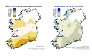
Provisional May 2025 rainfall as % of 1991 – 2020 monthly average (left) and provisional total monthly rainfall (mm) for May 2025 (right)
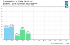
National gridded rainfall chart for 2025
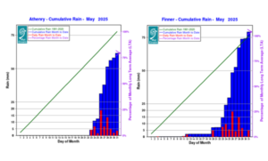
Cumulative rainfall totals at Athenry and Finner in May 2025, relative to monthly long term average
Temperature: Above average everywhere, warmest on record in parts of the South and West
All mean air temperatures across the country were above their LTA for the month. Deviations from mean air temperature ranged from +0.5 °C (11.2 °C, the month’s lowest mean temperature) at Dublin Airport, Co Dublin to +2.3 °C (12.5 °C mean temperature) at Knock Airport, Co Mayo.
Mean temperatures were as much as 14.2 °C (2.0 °C above its LTA) at Shannon Airport, Co Clare (its warmest May on record (length 79 years)).
The month’s highest temperature was reported at Newport, Co Mayo on Tuesday 13th, with a temperature of 24.8 °C. The month’s lowest air and grass minimum were recorded at Mount Dillon, Co Roscommon, with the lowest air temperature reported on Tuesday 6th with -0.9 °C, and the lowest grass minimum was -6.9 °C reported on Monday 5th.
More than half of stations reported ground frost. The number of days with ground frost ranged from zero days at a few stations to 21 days at Mount Dillon, Co Roscommon. Less than half of stations reported air frost. The number of days with air frost ranged from zero at Phoenix Park, Co Dublin to two at both Dunsany, Co Meath and Mount Dillon, Co Roscommon.
Along with Shannon Airport, four other stations had their warmest May on record (record lengths between 15 and 68 years). These were Roches Point, Co Cork (13.3 °C), Athenry, Co Galway (12.8 °C), Cork Airport, Co Cork (13.2 °C) and Knock Airport, Co Mayo (12.5 °C).
Six other stations in the Southwest and West had their warmest May since 2008. Sherkin Island, Co Cork had its highest daily maximum temperature for May on record with 22.6 °C on Thursday 1st (length 43 years). Fourteen stations had their highest mean maximum for May on record.
Sunshine: Very sunny everywhere, record sunshine in places
Shannon Airport, Co Clare (288.9 hours, record length 79 years) and Cork Airport, Co Cork (290.4 hours, 63 years) had their sunniest calendar month on record.
Johnstown Castle, Co Wexford (298.8 hours, record length nine years) and Gurteen, Co Tipperary (267.2 hours, record length nine years) had their sunniest May on record.
Valentia Observatory, Co Kerry had its sunniest May since May 1961. Casement Aerodrome, with 286.2 hours, had its second sunniest month on record, behind May 2020, and Dublin Airport had its second sunniest May behind 2020. All available sunshine totals were above their LTA.
Percentage of monthly sunshine values ranged from 150% (monthly sunshine total of 286.2 hours) at Casement Aerodrome, Co Dublin to 158% (monthly sunshine total of 288.9 hours) at Shannon Airport, Co Clare (its sunniest May on record (length 79 years)).
Monthly sunshine totals ranged from 267.2 hours at Gurteen, Co Tipperary** to 298.8 hours at Johnstown Castle, Co Wexford**. The highest number of daily sunshine hours recorded this month was 15.2 hours at Malin Head, Co Donegal on Sunday 18th; on Thursday 22nd at both Johnstown Castle, Co Wexford and Shannon Airport, Co Clare.
The number of dull days (*6) ranged from one at Casement Aerodrome, Co Dublin to five at Valentia Observatory, Co Kerry.
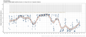
Hours of bright sunshine observed at nine stations for each day of the month of May 2025, grouped by province relative to the highest number of hours possible by end of month (shaded box).
Wind: Gales reported at one station on one day
Monthly mean wind speeds ranged from 4.8 knots (8.9 km/h) at Ballyhaise, Co Cavan to 10.8 knots (20.0 km/h) at Mace Head, Co Galway. Gales were reported on Sunday 25th at one station, Mace Head, Co Galway.
The highest 10-minute wind speed was 34 knots (63 km/h) reported at Mace Head, Co Galway on Sunday 25th. The month’s highest gust was reported at both Roches Point, Co Cork and Malin Head, Co Donegal on Sunday 25th and Thursday 29th respectively, with 43 knots (80 km/h).
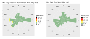
Wind roses for March 2025, sustained 10-minute mean and gust
Full PDF report and charts are available here
Issued by Met Éireann on Wednesday 4th June 2025. This report is based on available preliminary data from 25 principal weather stations operated by Met Éireann. Synoptic station data is daily, which is midnight to midnight UTC. Long-Term Averages (LTAs) and “average” refer to the period 1991-2020.
*0 A rain day is a day with 0.2 mm or more of rainfall
*1 A wet day is a day with 1.0 mm or more of rainfall
*2 A very wet day is a day with 10.0 mm or more of rainfall
*3 A climatological dry periods is a period of 15 or more consecutive days to none of which is credited 1.0 mm or more of precipitation (i.e. daily tot < 1.0 mm)
*4 An absolute drought is a period of 15 or more consecutive days to none of which is credited 0.2 mm or more of precipitation.
*5 A partial drought is a period of at least 29 consecutive days, the mean daily rainfall of which does not exceed 0.2 mm.
*6 A dull day is a day with less than 0.5 hours of sunshine.
**Sunshine data is from the Autosol Network. LTAs for these sites are currently not used for comparison purposes. For more information, contact Met Éireann at 01-8064200 or e-mail: enq@met.ie.