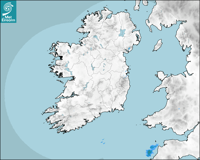

Latest Rainfall Radar showing live precipitation and the last 90 minutes precipitation over Ireland, updated every 5 minutes. Precipitation can be rain, hail or snow. Accumulations can refer to rainfall only.
Lightning strikes, when they occur, are displayed as a cross. Initially, they are red but change to orange and then yellow after a period, then disappear © Met Office ATDNet.
Ground Clutter may appear (South Co. Dublin), bright bands and spokes may also be present in images. They are artefacts (false echoes) of rainfall radar systems and should be ignored. Further information on Radar here
Met Éireann forecasters manually produce the weather icons for midday and midnight to reflect the predicted major weather type for these times.
The rainfall forecast is direct model output from Numerical Weather Prediction models but is a guideline only. Rain refers to precipitation, which can be rain, sleet or snow. It forecasts how much rain will fall (in mm) hourly during the previous hour (accumulations), then in 3 hourly and finally 6 hourly accumulations up to 7 days. This service is based on data and products of the HARMONIE-AROME and the European Centre for Medium-range Weather Forecasts (ECMWF) models.
The wind is direct model output from Numerical Weather Prediction models but is a guideline only. It forecasts the strength of the wind (in knots and km/h) at 10m for the top of each hour, in hourly, then 3 hourly and finally 6 hourly intervals up to 7 days. The wind arrow tip points in the direction the wind is blowing and the tail length indicates wind strength. However, in the text forecast below, it is described as where it is blowing from. This service is based on data and products of the HARMONIE-AROME and the European Centre for Medium-range Weather Forecasts (ECMWF) models.
The temperature is direct model output from Numerical Weather Prediction models but is a guideline only. It forecasts air temperature on land and over sea in °C for the top of each hour, 3 hourly and finally 6 hourly intervals up to 7 days. Minus zero (-0) indicates values between 0 to -0.5°C. This service is based on data and products of the HARMONIE-AROME and the European Centre for Medium-range Weather Forecasts (ECMWF) models.
The Mean Sea Level Pressure (MSLP) is direct model output from Numerical Weather Prediction models but is a guideline only. It forecasts the MSLP in hecto Pascals (hPa) for the top of that hour initially in 3 hourly intervals, then 6 hourly. This service is based on data and products of the HARMONIE-AROME and the European Centre for Medium-range Weather Forecasts (ECMWF) models.
National Forecast
03 March 2026 14:30
Today
Bright and sunny today but feeling a little chilly in any shaded areas. Cloudier conditions will develop near the south coast, gradually extending northwards over parts of Munster and south Leinster as the day goes on, with patchy rain and drizzle developing in these parts towards evening. Highs of 9 to 12 degrees in light easterly breezes.
Tonight
Clear spells in the west and north at first tonight, with a touch of frost possible early on. Cloudier conditions in the east and south, with patchy rain, drizzle and mist will extend to most parts overnight. Lowest temperatures of 0 to 5 degrees, coldest early in the night under clearer breaks in the west and north, in light to moderate south to southeast breezes.
Tomorrow
Mostly cloudy tomorrow Wednesday, with mist and fog lingering in places, but some bright or sunny breaks in the mix too. While there will be a lot of dry weather overall, patchy drizzle will occur, and a few showers will develop in the west and northwest towards evening. Highest temperatures of 10 to 14 degrees in light to moderate southerly winds.
Met News

04th February 2026
Climate Statement for January 2026
Cool, very wet in the South and East January 2026 ... more

29th January 2026
New Masters in Artificial Intelligence for Weather and Climate Change launched
A new MSc programme co-delivered by Met Éireann a... more

13th January 2026
Met Éireann presents two awards at action-packed Stripe YSTE
Met Éireann was once again delighted to take part... more

06th January 2026
Annual Climate Statement for 2025
Second warmest year on record with above average r... more