Sea Area Forecast
Forecast valid from: 18:00, Thursday 05 March 2026 until 18:00, Friday 06 March 2026
Small Craft Warning
Northwesterly winds will reach force 6 or higher this evening and early tonight on Irish coasts from Fair Head to Wicklow Head to Mizen Head.
Gale Warning
North to northwest winds will reach gale force 8 at times this evening (Thursday) on Irish coastal waters from Strangford Lough to Howth Head to Hook Head and on the Irish Sea.
Meteorological Situation at 15:00 UTC
Ireland lies in a fresh to near gale force northwesterly airflow between an anticyclone of 1037hPa centred near the Azores and a broad area of low pressure over Greenland. A slow-moving cold front lying over the country will clear eastwards this evening, and a ridge of high pressure will build from the west.
Gale Warning: In effect
Small Craft Warning: In effect
Heavy Swell (>4m) : No
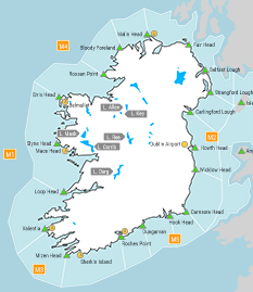
Forecast for Fair Head to Wicklow Head to Mizen Head and for the Irish Sea
Wind: Northwesterly force 5 to 7, reaching gale force 8 at times. Soon decreasing force 4 to 6. Later decreasing northerly or variable force 2 to 4.
Weather: Rain, persistent and heavy at times. Mist too. Becoming fair soon.
Visibility: Decreasing moderate or poor in precipitation and mist.
Forecast for Mizen Head to Erris Head to Fair Head
Wind: Decreasing northwesterly force 3 or 4 imminent. Soon backing west to southwest. Later increasing southwest force 4 to 6.
Weather: Mostly fair, with isolated showers.
Visibility: Decreasing moderate or poor in precipitation.
Outlook for a further 24 hours until 18:00, Saturday 07 March 2026
Fresh to near gale force southerly winds in the west and north. Light to moderate southerly or variable winds elsewhere. Weather: Cloudy to fair with isolated showers.
Forecast issued at: 18:00, Thursday 05 March 2026
All times are local unless specified