Réamhaisnéis limistear na farraige
Forecast valid from: 01:00, Wednesday 04 March 2026 until 00:00, Thursday 05 March 2026
Small Craft Warning
Southerly winds will reach force 6 at times on Wednesday evening and early night on coats from Mizen Head to Malin Head to Carnsore Point
Gale Warning
Nil
Meteorological Situation at 21:00 UTC
An anticyclone of 1031 HPa centered between England and Denmark, maintains a light to fresh southeast to south airflow over Ireland. A weak warm front near the south coast moves northwards.
Small Craft Warning: In effect
Heavy Swell (>4m) : No
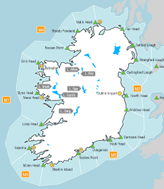
Forecast for Mizen Head to Slyne Head to Malin Head
Wind: Southerly force 4 or 5, later occasionally reaching force 6
Weather: Fair. Rain developing on Wednesday evening and becoming persistent in the early night
Visibility: Good, decreasing moderate or poor in rain
Forecast for Malin Head to Howth Head to Carnsore Point and for the Irish Sea
Wind: East to southeast force 3 to 5, soon backing south to southeast, later becoming mainly southerly and increasing force 5 or 6 in the evening and early night.
Weather: Patchy drizzle overnight. Fair on Wednesday apart from a little drizzle and mist
Visibility: Moderate to poor in drizzle or mist, otherwise good.
Forecast for Carnsore Point to Roches Point to Mizen Head
Wind: East to south-east force 2 to 4, soon becoming south to south-east, later becoming mainly southerly and increasing force 3 to 5
Weather: Patchy drizzle and mist at times
Visibility: Moderate to good, decreasing moderate or poor in drizzle and mist
Outlook for a further 24 hours until 00:00, Friday 06 March 2026
Moderate to fresh southerly winds, Strong northwesterly developing overnight on western coasts and extending to all coasts on Thursday, occasionally reaching gale force on eastern coasts later. Rain spreading eastwards overnight and clearing slowly on Thursday with fair weather following.
Forecast issued at: 01:00, Wednesday 04 March 2026
All times are local unless specified