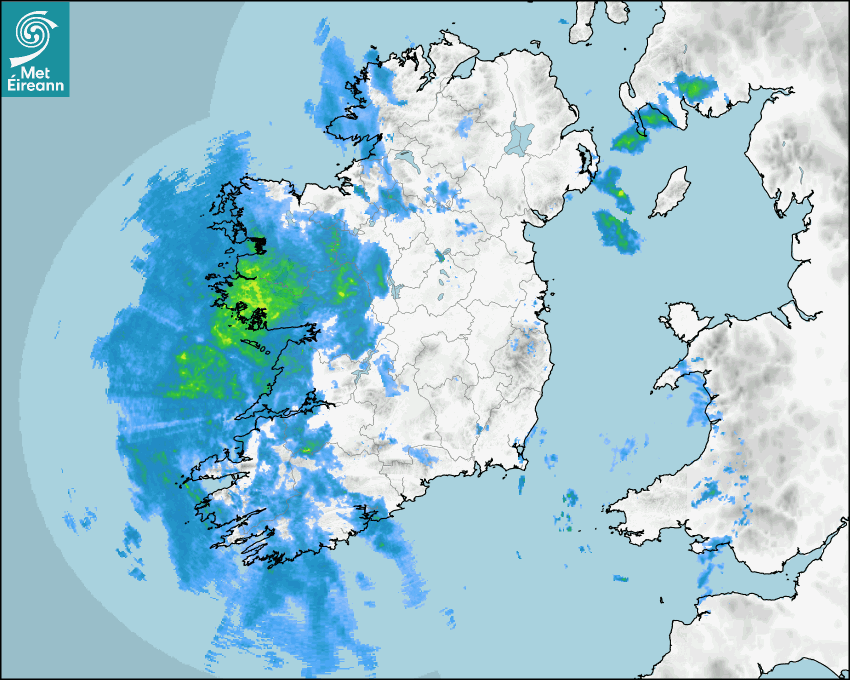

Latest Rainfall Radar showing live precipitation and the last 90 minutes precipitation over Ireland, updated every 5 minutes. Precipitation can be rain, hail or snow. Accumulations can refer to rainfall only.
Lightning strikes, when they occur, are displayed as a cross. Initially, they are red but change to orange and then yellow after a period, then disappear © Met Office ATDNet.
Ground Clutter may appear (South Co. Dublin), bright bands and spokes may also be present in images. They are artefacts (false echoes) of rainfall radar systems and should be ignored. Further information on Radar here
Met Éireann forecasters manually produce the weather icons for midday and midnight to reflect the predicted major weather type for these times.
The rainfall forecast is direct model output from Numerical Weather Prediction models but is a guideline only. Rain refers to precipitation, which can be rain, sleet or snow. It forecasts how much rain will fall (in mm) hourly during the previous hour (accumulations), then in 3 hourly and finally 6 hourly accumulations up to 7 days. This service is based on data and products of the HARMONIE-AROME and the European Centre for Medium-range Weather Forecasts (ECMWF) models.
The wind is direct model output from Numerical Weather Prediction models but is a guideline only. It forecasts the strength of the wind (in knots and km/h) at 10m for the top of each hour, in hourly, then 3 hourly and finally 6 hourly intervals up to 7 days. The wind arrow tip points in the direction the wind is blowing and the tail length indicates wind strength. However, in the text forecast below, it is described as where it is blowing from. This service is based on data and products of the HARMONIE-AROME and the European Centre for Medium-range Weather Forecasts (ECMWF) models.
The temperature is direct model output from Numerical Weather Prediction models but is a guideline only. It forecasts air temperature on land and over sea in °C for the top of each hour, 3 hourly and finally 6 hourly intervals up to 7 days. Minus zero (-0) indicates values between 0 to -0.5°C. This service is based on data and products of the HARMONIE-AROME and the European Centre for Medium-range Weather Forecasts (ECMWF) models.
The Mean Sea Level Pressure (MSLP) is direct model output from Numerical Weather Prediction models but is a guideline only. It forecasts the MSLP in hecto Pascals (hPa) for the top of that hour initially in 3 hourly intervals, then 6 hourly. This service is based on data and products of the HARMONIE-AROME and the European Centre for Medium-range Weather Forecasts (ECMWF) models.
Réamhaisnéis Náisiúnta
01 March 2026 10:30
Inniu
Dull, misty and breezy today with outbreaks of rain and drizzle. Becoming wetter and windier through the day with the rain heaviest in the south and west. Some spot flooding is possible. Southerly winds will increase fresh to strong and gusty, reaching near gale force at times near coasts. Highest temperatures of 9 to 12 degrees.
Anocht
Tonight, the wet and blustery conditions will gradually clear eastwards. Becoming drier with clear spells over the western half of the country, with cloud and patchy rain lingering towards morning in the east. Fresh to strong southerly winds will ease mostly light westerly with the rain. Lowest temperatures of 3 to 7 degrees.
Amárach
Tomorrow morning, any lingering cloud and patchy rain in the east will clear early on, with a largely dry and bright start elsewhere. Becoming cloudier and breezy through the morning with showers moving in from the northwest and turning heavy at times. The showers will ease as they move southeastwards with dry and sunny conditions following later in the afternoon. Highest temperatures of 9 to 12 degrees with freshening southwest winds that will ease light northwesterly later in the day.
Met News

04ú Feabhra 2026
Climate Statement for January 2026
Cool, very wet in the South and East January 2026 ... léigh níos mó

29ú Eanáir 2026
New Masters in Artificial Intelligence for Weather and Climate Change launched
A new MSc programme co-delivered by Met Éireann a... léigh níos mó

13ú Eanáir 2026
Met Éireann presents two awards at action-packed Stripe YSTE
Met Éireann was once again delighted to take part... léigh níos mó

06ú Eanáir 2026
Annual Climate Statement for 2025
Second warmest year on record with above average r... léigh níos mó